


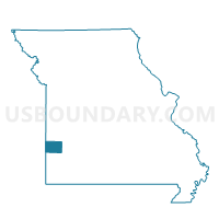
Central Voting District, Barton County, Missouri
About
Outline

Summary
| Unique Area Identifier | 607078 |
| Name | Central Voting District |
| County | Barton County |
| State | Missouri |
| Area (square miles) | 54.41 |
| Land Area (square miles) | 54.16 |
| Water Area (square miles) | 0.25 |
| % of Land Area | 99.55 |
| % of Water Area | 0.45 |
| Latitude of the Internal Point | 37.51828900 |
| Longtitude of the Internal Point | -94.41793540 |
Maps


Graphs
Select a template below for downloading or customizing gragh for Central Voting District, Barton County, Missouri


Neighbors
Neighoring Voting District (by Name) Neighboring Voting District on the Map
- Barton City Voting District, Barton County, MO
- Lamar Voting District, Barton County, MO
- Leroy Voting District, Barton County, MO
- Nashville Voting District, Barton County, MO
- Northfork Voting District, Barton County, MO
- Ozark Voting District, Barton County, MO
- Southwest Voting District, Barton County, MO
- Union Voting District, Barton County, MO
Top 10 Neighboring County Subdivision (by Population) Neighboring County Subdivision on the Map
- Lamar township, Barton County, MO (1,490)
- Ozark township, Barton County, MO (1,078)
- South West township, Barton County, MO (642)
- Central township, Barton County, MO (561)
- Union township, Barton County, MO (507)
- Nashville township, Barton County, MO (390)
- Northfork township, Barton County, MO (263)
- Barton City township, Barton County, MO (250)
- Leroy township, Barton County, MO (223)